Have Java installed on your PC? Click the pic for timelapse video

Via theoildrum.com KAC/UCF [University of Central Florida] and Chuck Watson are forecasting, based on their damage models, that the Qalhat (Sur) [Oman] LNG terminal will be out for 20-30 days and the Mina al Fahal [Oman] oil terminal will be down for 10-15 days--all of this assuming they are built to US standards.
Stratfor.com
A Category 5 cyclone with winds of up to 195 mph is heading toward one of the world’s most productive energy basins, threatening local devastation and global disruption at a point at which oil prices are already flirting with record highs. For once, the region in question is not the Gulf of Mexico. There is cause for concern; Cyclone Gonu is headed directly for the Strait of Hormuz.
The cyclone is rotating counterclockwise — as it would in the Gulf of Mexico — meaning that, should it enter the Persian Gulf, the gulf’s west coast would suffer the most serious damage. Along the west coast, low-lying areas are the norm, and there are few barrier islands like the ones that line the Gulf of Mexico to absorb much of the storm surge that could therefore penetrate miles inland.
Like all weather phenomena, hurricanes and cyclones are notoriously fickle, so there is (thankfully) no guarantee Gonu will enter the Persian Gulf, much less wreck it. But there are two facilities that bear specific mention: the Ras Tanura and Ras al-Juaymah oil loading platforms in Saudi Arabia. So far, the chances of either of these facilities suffering a direct hit are very slim — Gonu is still 750 miles away from those export points — but they collectively pump nearly 10 million barrels per day (bpd) of crude. These facilities, while critical to global energy supplies and — due to their size — largely immune to terrorist attacks, are not particularly hurricane resistant. After all, they were built in an area where such storms are almost unheard of. Other (hardly insignificant) energy installations dot the region in Saudi Arabia, Qatar and the United Arab Emirates — most of them on the west coast. Luckily, there is little offshore production in the Persian Gulf — unlike in the Gulf of Mexico — so there is unlikely to be much permanent damage to the oil production facilities themselves.
More likely is shipping disruption. Right now, Gonu is on a collision course with the Strait of Hormuz, a major chokepoint that transits some 17 million bpd of crude. Within the next few hours, the tankers and supertankers — not to mention the massive container ships that often visit regional hubs in the United Arab Emirates — that ply that route will be scurrying out of the storm’s way. In the Gulf of Mexico, such storm-dodging is an annual ritual that is no major concern, but in the world’s “Cradle of Oil,” this is a completely new sport, and even a short disruption with minimal damage is sure to send the price of a barrel of crude sharply upward.
Currently the “best guess” indicates Gonu will slowly lose force to be “only” Category 3 when it makes initial landfall in Oman, forecast for June 5 at 6 p.m. local time.
36 foot waves forecast
MAXIMUM SIGNIFICANT
WAVE HEIGHT AT 051200Z IS 36 FEET.
They not prepared for this type of storm

What people need to worry about is that the Persian Gulf has not been hit by anything stronger than a tropical storm EVER. Everything is built down by the waters edge and nothing is designed to withstand even a minimal hurricane. What this means is, we could see massive oil infrastructure damage, and gasoline and other oil products become UNAVAILABLE at any price. At the least, oil deliveries will be disrupted and delayed for possibly weeks. Get your gas now or risk having none.
From Dr. Jeff Masters @ Wunderground
The Storm surge shown (10-15 ft) will almost certainly hit the Iran coast - even if the storm weakens to a strong CAT 2 late Tuesday (NY time). The Eastern tip of Oman will likely also experience 10-15 foot surge due to the close proximity of the storm track. Further up the Gulf, before reaching the Straits of Hormuz - storm surge heights of 1-4 feet are expected on the Oman side, and 4-possibly 6 feet on the Iranian side near the entrance to the Straits. Significant wave heights will be 20-30 feet, dropping to 15 feet near the Straits.
This is an unprecedented event. NO CYCLONE has ever entered the Gulf of Oman. And there are no custom 'storm surge' models available for that area. This forecast is based on my experience and subjective analysis of the seabed slope and storm surge interaction with the sea floor. Considering the region has never experienced a hurricane, let alone a strong one it is highly unlikely the loading facilities or platforms were constructed to withstand the forces - both wave action and wind force - that they will experience. Significant, damage will occur. How much long term damage, and the volumes associated with it - can not be determined at this time.
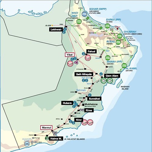
Since Oman's getting hit as I type this, here is their (electrical?) energy infrastructure
MUCH, MUCH more information at theoildrum.com here and here


![[PDA - Pledge For Peace - Sign the Petition.]](http://pdamerica.org/images/ads/P4P_button.jpg)